

Nationally designated historic site Namame Tombs 지도, 미야자키 시, 일본
코멘트
위치 Nationally designated historic site Namame Tombs 지도, 미야자키 시, 일본. 십진수 형식의 지리 좌표와도, 분, 초. 이곳을 방문한 방문자의 사진, 주소 및 평균 평점.
사진
위치 Nationally designated historic site Namame Tombs
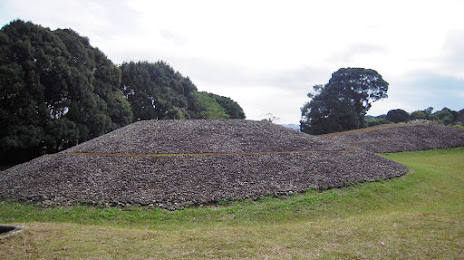
Nationally designated historic site Namame Tombs — 에 위치한 지역 명소 Miyazaki, 880-2101, Japan 그리고 카테고리에 속합니다 — historical landmark. 이 장소에 대한 평균 방문자 평점 — 3.9 (~에 따르면 34 등급, 오픈 소스 및 2022년 관련 정보).
정확한 위치 — Nationally designated historic site Namame Tombs, 빨간색 마커로지도에 표시.
당신은 할 수 있습니다 길찾기 Nationally designated historic site Namame Tombs 내 위치의 지도에서.
그 밖에 흥미로운 점 미야자키 시? 시티페이지에 가시면 모든 명소를 보실 수 있습니다.
좌표
Nationally designated historic site Namame Tombs, 일본 십진수 형식의 좌표: 위도 — 31.95003811427005, 경도 — 131.3856300976862. 도, 분, 초로 변환 할 때 Nationally designated historic site Namame Tombs 다음 좌표가 있습니다: 31°57′0.14 북위 과 131°23′8.27 동경.
가까운 도시
근처에 위치한 가장 큰 도시:
- 미야코노조 시 — 40 킬로미터
- 노베오카 시 — 78 킬로미터
- 가고시마 시 — 88 킬로미터
- 야쓰시로 시 — 101 킬로미터
- 구마모토 시 — 119 킬로미터
- 오이타 시 — 148 킬로미터
- 벳푸 시 — 152 킬로미터
- 오무타 시 — 153 킬로미터
- 나가사키 시 — 171 킬로미터
- 구루메 시 — 177 킬로미터
- 후쿠오카 시 — 208 킬로미터
- 사세보 시 — 211 킬로미터
- 기타큐슈 시 — 224 킬로미터
- 우베 시 — 227 킬로미터
- 시모노세키시 — 231 킬로미터
- 호후 시 — 237 킬로미터
- 마쓰야마 시 — 247 킬로미터
- 야마구치 시 — 251 킬로미터
- 이와쿠니 시 — 260 킬로미터