

Tottori Prefecture Embedded Cultural Properties Center 지도, 돗토리 시, 일본
코멘트
위치 Tottori Prefecture Embedded Cultural Properties Center 지도, 돗토리 시, 일본. 십진수 형식의 지리 좌표와도, 분, 초. 이곳을 방문한 방문자의 사진, 주소 및 평균 평점.
사진
위치 Tottori Prefecture Embedded Cultural Properties Center
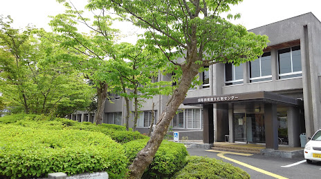
Tottori Prefecture Embedded Cultural Properties Center — 에 위치한 지역 명소 Japan, 〒680-0151 Tottori, Kokufucho Miyanoshita, 1260 埋蔵文化財センター 그리고 카테고리에 속합니다 — archaeological museum. 이 장소에 대한 평균 방문자 평점 — 3.6 (~에 따르면 19 등급, 오픈 소스 및 2022년 관련 정보).
정확한 위치 — Tottori Prefecture Embedded Cultural Properties Center, 빨간색 마커로지도에 표시.
당신은 할 수 있습니다 길찾기 Tottori Prefecture Embedded Cultural Properties Center 내 위치의 지도에서.
그 밖에 흥미로운 점 돗토리 시? 시티페이지에 가시면 모든 명소를 보실 수 있습니다.
좌표
Tottori Prefecture Embedded Cultural Properties Center, 일본 십진수 형식의 좌표: 위도 — 35.48001706517269, 경도 — 134.25927452480275. 도, 분, 초로 변환 할 때 Tottori Prefecture Embedded Cultural Properties Center 다음 좌표가 있습니다: 35°28′48.06 북위 과 134°15′33.39 동경.
가까운 도시
근처에 위치한 가장 큰 도시:
- 요나고 시 — 82 킬로미터
- 히메지 시 — 86 킬로미터
- 오카야마 시 — 98 킬로미터
- 마츠모토 — 107 킬로미터
- 구라시키 시 — 110 킬로미터
- 산다 시 — 112 킬로미터
- 아카시 시 — 117 킬로미터
- 고베 시 — 125 킬로미터
- 다카라즈카 시 — 128 킬로미터
- 가와니시 시 — 130 킬로미터
- 니시노미야 시 — 131 킬로미터
- Itami — 132 킬로미터
- 아마가사키 시 — 136 킬로미터
- 도요나카 시 — 137 킬로미터
- 후쿠야마 시 — 138 킬로미터
- 스이타 시 — 142 킬로미터
- 다카쓰키 시 — 145 킬로미터
- 오사카 시 — 146 킬로미터
- 모리구치 시 — 147 킬로미터